
Introduction to GPS
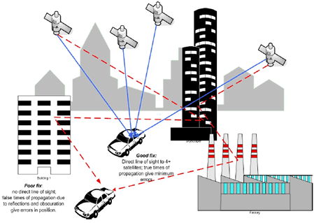
The Global Positioning System (GPS) is a satellite-based navigation system that requires 24 orbiting satellites to function, each of which makes two circuits around the Earth every 24 hours. These satellites transmit three bits of information - the satellites number, its position in space, and the time the information is sent. These signals are picked up by the GPD receiver, which uses this information to calculate the distance between it and the GPS satellites. With signals from three or more satellites, a GPS receiver can triangulate its location on the ground (i.e. longitude and latitude) from the known position of the satellites. With 4 or more satellites, a GPS receiver can determine a 3D position (i.e. latitude, longitude, and elevation). In addition, a GPS receiver can provide data on your speed and direction of travel. Anyone with a GPS receiver can access the system. Because GPS provides real-time, three dimensional positioning, navigation, and timing 24 hours a day, 7 days a week, all over the world, it is used in numerous applications, including GIS data collection, surveying, tracking and mapping. Generally speaking GPS does not work indoors and so while it is the best technology for outdoor tracking it may be supplemented or replaced by RFID if accurate indoor tracking is required. GPS may also be used in conjunction with RFID in a yard or campus environment as the proximity of buildings can adversely affect the GPS signal as explained below.
|